

| Contact Us | Directions
|
| Contact Us | Directions |
|
Blue Ridge Center | Nature | Farming | History | Learning from the Land |
|
|
|
Nature
Water • Geology • Weather • Land Water Piney Run is fed by one major tributary, Sweet Run, which drains from the Blue Ridge's eastern ridgeline. A smaller, unnamed seasonal run drains west from Short Hill Mountain and converges with Piney Run on our land. A variety of seeps, perennial springs, and seasonal streams feed Piney Run and its tributaries. Both Piney Run and Sweet Run are remarkably diverse and are inhabited by numerous species of fish. Sweet Run contains seven species and Piney Run contains 16 species. Fish in Sweet Run are less diverse due to its substantially colder water than Piney Run, and Piney Run is considered very diverse for a small first order stream. The Flora & Fauna section contains a fish species list. The streams, ponds, and wetlands of the Blue Ridge Center host a large number of reptiles and amphibians, including the Virginia-listed threatened wood turtle. The range of water habitats also ensures insect and bird diversity. Good water quality is essential to healthy ecological systems. Industrial pollutants, agricultural and residential runoff, septic system leakage and acid rain can all contribute to water quality decline. The Blue Ridge Center waterways benefit from regular monitoring, sampling, and testing by a number of our educational partners. Geology
The land of the Blue Ridge Center is part of the Harpers Ferry quadrangle, covering a portion of the Blue Ridge-South Mountain area. Elevations range from 500 ft. on the eastern edge to nearly 1,000 ft. atop the ridgeline. The Blue Ridge consists of up-thrust belts of rock that have been subjected to intense metamorphic deformation, and a bedrock of sandstone, metabasalt, and gneiss underlies the Blue Ridge Center property. Through time, these materials erode, sloughing off the main ridges in blocks and plates. The western half of our property, as a result, is composed of steep ledges surrounded by immense fields of jagged boulders. The thin rocky soils of these upland zones give way to the richer top soils in the bottomland and riparian environment found along Piney Run. The Blue Ridge Mountain's oldest rock is Proterozoic gneiss and igneous intrusives that have been intensively folded and faulted. As in many places along the Blue Ridge, this crushed and distorted older rock is thrust-faulted up and over younger rock. Ancient layered bedrock outcrops can be seen in northern Virginia and on South Mountain in Maryland. Both the summit of South Mountain and the Blue Ridge of Virginia are composed mostly of quartzite and greenstone. Visit the U.S. Geological Survey Web site for maps and reports on lands surrounding the Blue Ridge Center. Weather
In our region, the present climate is temperate with four distinct seasons. Virginia's average temperature varies from 36 degrees Fahrenheit during winter months, to mid 50's in spring and fall, to mid 70's in summer. Virginia's average annual total precipitation is 44 inches. The state's average annual snowfall varies form 9 to 27 inches, all according to the Virginia Climatology Office. This temperate climate — with its balance of hot and cold, wet and dry weather — largely determines our region's flora and fauna. It prevents the 900 acres at the Blue Ridge Center from turning into searing desert, rain forest, or frigid tundra. Oaks and hickories, white-tail deer, black bears (and local humans, for that matter) have all adapted themselves well to living in Virginia's temperate zone. However, the moderate climate we take so for granted today is very different from our region's past climates. Over the last few million years, climate conditions in Virginia have ranged from the subtropical to the sub-arctic. Flora and fauna appropriate to those ancient climates evolved on the landscape during each of those climactic periods. For example, cold-loving mastodons probably roamed Loudoun County at the height of the last ice age, just 18,000 years ago. There is also a growing body of evidence that we stand on the verge of a future climate that may be drastically different from the temperate conditions we currently enjoy. The majority of climate scientists worldwide agree that a sudden shift in climate may now be underway, one not likely caused by natural phenomena. The Phenonmenon of Climate Change Scientists worry that global warming triggered by our industrial age is starting to cause ice caps and glaciers to melt, oceans to rise, and heat-sensitive plants and animals to migrate northward at a quickening pace. While no one can say for sure how climate change will impact the Earth or Loudoun County in the 21st century, many scientists are urging us to take action to curb its worst impacts. While the gigantic forces at play in global warming may seem overwhelming to us, it's important to remember that each of us contributes in our own small way to the problem of climate change, and so each of us can also contribute to its solutions. Geology and Climate
The first force is Geology: Heat rising from deep inside the earth acts as an engine to make continental plates drift apart and collide, causing great mountain chains to arise and land masses to sink into the sea. The second primal force is climate. Climate is different from weather. Weather is what happens from moment to moment in the earth's atmosphere. When you look out your window, you see weather: Is it rainy or snowy, cloudy or sunny, windy or still, cold or hot at your particular location? Climate, however, is defined as the long term average of weather over a wider region. Climate is determined by measuring daily weather conditions over an extended period of time. It is the averaging out of regional patterns of drought, precipitation, temperature, cloud cover, and wind speed over centuries. Climate is so powerful in the long term that it actually counteracts the gargantuan mountain building forces of geology. In Loudoun County, for example, climate acting over millions of years whittled away the ancient Appalachian Mountain chain, cutting down what some scientists say were 30,000 foot peaks (that's as high as today's Himalayans) to the current size of the Blue Ridge in northern Virginia — just over 1,000 feet above sea level. Land
To the west, the Blue Ridge rises to roughly 1,000 feet and is capped by the Appalachian National Scenic Trail to the east, the property ends at Virginia Route 671, a road that runs the valley floor north-to-south. Further east is Short Hill Mountain. The lands of the Blue Ridge Center include young recovering upland forest, wetlands, bottomland, meadows, farmland, ponds, and streams. Upland areas are rugged with rocky outcrops. Several springs originate within the property and drain into Sweet Run and Piney Run, which in turn empty into the Potomac River. Elevations on the land range from 500 feet to 1,000 feet above sea level. The underlying valley geology consists of hornblende gneiss. The farmland portion of the property has, for decades, been planted in corn and soy beans after a much longer history as a dairy farm. Some parts of the upland forest were logged as recently as 1995, and these areas are laced with a network of haul roads. The ridgeline section of the land has remained untouched since being logged in the 1800s, and consists of a maturing oak-poplar forest. The woodlands are rich with life, with many native species of trees, shrubs, and wildflowers. Having been introduced intentionally or accidentally, invasive species such as garlic mustard and multiflora rose are intermixed with native plants.
The Blue Ridge Center | Nature | Farming |
History |
Learning from the Land © Copyright 2001-2004, Blue Ridge Center for Environmental Stewardship. |
||||||||||||



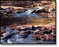 The Blue Ridge Center for Environmental Stewardship is located in the Potomac Watershed, a region covering more than 14,670 square miles. The Potomac River is 383 miles long and breaks through the Blue Ridge Mountains at Harpers Ferry. This is where Piney Run, which drains the land of the Blue Ridge Center, empties into the river at Potomac Wayside, downriver from Harpers Ferry.
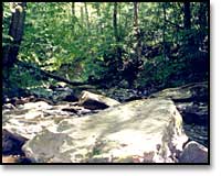 It is geology that first shapes the land. Topography, rocks, soils, and drainage help determine the nature of ecological systems and the unfolding patterns of human exploration, settlement, and land use. The Blue Ridge Center's research explores the interrelated web of geological, environmental, and human forces that have shaped ongoing relationships on our land.
 The Climate of Loudoun County and at the Blue Ridge Center
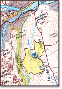 The Blue Ridge Center is on the westernmost edge of the Piedmont region of northern Virginia, at the narrowing north end of a valley known as "Between the Hills." The land is 20 miles from both Leesburg, Virginia, and Frederick, Md., and two miles south of Harpers Ferry, W. Va., where the Potomac and Shenandoah Rivers converge.