|
Historical & Cultural Stewardship
 HISTORICAL STRUCTURES
SUMMARY OF FINDINGS
In the early 19th century, prior to the Civil War, the land now owned by the Robert and Dee Leggett Foundation, and probably much of the rest of the Loudoun Valley as well, was heavily settled. The several homesteads and their inhabitants on the Foundation's property probably took part in wider social, political, and economic systems that encompassed the valley and county.
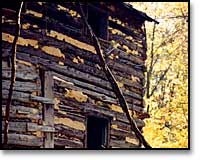
The most visible reminders of the once thriving agrarian lifestyle on the 900 acre Foundation property are its buildings. A main house is surrounded by eight associated structures, including an outhouse, springhouse, sheds, stable, and destroyed barn. Elsewhere on the land is a 19th century stone house, several log cabins, chicken coops, root cellars and other structures and foundations. In all, 33 sites show evidence of human occupation.
Most of the current structures were built originally, or extensively rebuilt, around the Civil War period. The structures are mostly of hewn logs, wood frame, or stone. A few, such as the main house, are in relatively good condition, while others are in various states of ruin.
Stone fences, a well, abandoned farm machinery, canalized lowland areas, a possible charcoal heath, haul roads, and young forests add to the evidence for substantial populations and heavy land-use in the valley prior to quite recent times.
STUDIES TO DATE
The Blue Ridge Center, in conjunction with Millsaps College, is conducting an in-depth archaeological survey of the 900 acre Foundation property. Dr. Michael Galaty is heading up the project from Millsaps College, with additional support from Thunderbird archaeological Associates. The project was begun in summer 2000 with a phase I reconnaissance of the entire property. The land was walked and surface-collected, with some areas shovel-tested. The well-known historic farmsteads on the property were avoided and not shovel-tested to preserve their archaeological integrity.
In autumn 2000, photos were taken of interesting sites, and global positioning systems were employed to accurately pinpoint features. A descriptive database is being created which includes historical aerial photos, and historical maps.
Phase II investigation began in 2001, with mapping, surface collection, and test excavations of the land's large barn site.
 return to top
Our Farm |
Our Land |
Blue Ridge Press
News from the Ridge |
Contact Us |
Site Map |
Home
© Copyright 2001, Blue Ridge Center for Environmental Stewardship.
All rights reserved.
|