|
Scientific and Natural Stewardship
WATERWAYS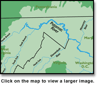
 BRCES Waters Close Up BRCES Waters Close Up
Water Quality
The Blue Ridge Center for Environmental Stewardship is located in the Potomac Watershed, a region covering more than 14,670 square miles, including the District of Columbia, and parts of Maryland, Pennsylvania, West Virginia, and Virginia.
The Potomac River is 383 miles long, with headwaters in the Allegheny Mountains. Its north and south branches flow together 15 miles west of Cumberland, Maryland. The combined streams form the Maryland-West Virginia, and Maryland-Virginia border. The river breaks through the Blue Ridge Mountains at Harpers Ferry, W.Va., and tumbles across the Piedmont Plateau fall line at Great Falls, Virginia. Below Washington, D.C., in its final 117 miles, the Potomac is considered a tidal estuary. The river empties into the Chesapeake Bay and the Atlantic Ocean.
The Potomac is fed by several large tributaries including the Shenandoah, Monocacy, Cacapon, and Conococheagure Rivers, and dozens of smaller streams; among them are the colorfully named Antietam, Fifteen Mile, Little Tonoloway, Piney Run, Catoctin, and Big Pipe Creeks. The health of all of these tributaries contributes to the health of the Potomac River and the entire watershed.

Our Farm |
Our Land |
Blue Ridge Press
News from the Ridge |
Contact Us |
Site Map |
Home
© Copyright 2001, Blue Ridge Center for Environmental Stewardship.
All rights reserved.
|